This article is a co-write by Charla Johnson & Jamie Jones.
“Loving black culture has never meant loving black people, too. Loving black culture risks loving the life out of it.”
Wesley Morris, The 1619 Project, The New York Times
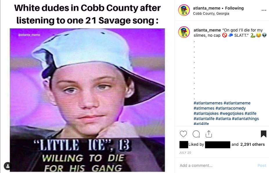
Oh, Little Ice. Look at you, with your street name and your sideways cap. You’re just another privileged white boy appropriating black culture—but you don’t seem to realize this.
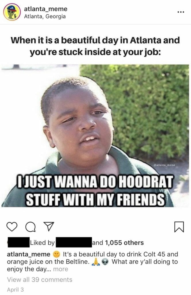
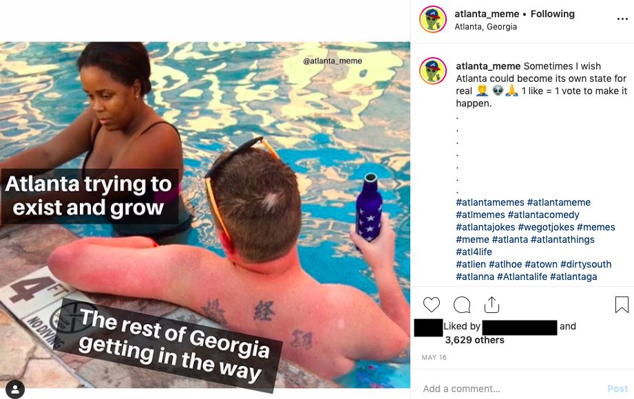
Y’all know the @atlanta_memes account on Instagram? It’s got over 30k followers, so chances are you’ve come across it. The account chronicles many of the joys and heartaches particular to life in Atlanta: traffic, wings, batshit weather, the relentless tribulations of Atlanta sports fandom, etc. If you’ve got any ATL in you at all, you’re gonna relate and, on occasion, chuckle out loud.
Of course, you may also find yourself gaping blankly, brows furrowed, eyes asquint, at the digital blackface staring back at you from the screen. By digital blackface, we mean white people using GIFs, memes, emojis, and other images of black people to express emotional reactions online (Google that shit). Scroll through their posts, and you’ll find that while the two men behind @atlanta_memes seem to genuinely love both this city and black culture (they seem like nice dudes tbh), they also create memes that rely on stereotypes of blackness and that can, at times, even fetishize violence in communities of color.
These gentlemen are, unsurprisingly, both white; and as evidenced by the myriad memes they’ve made to shit on OTP, both were reared inside the perimeter—one in Decatur (which began gentrifying decades ago) and the other in Avondale Estates (currently the seventh-richest city in Georgia).
But back to Little Ice. We begin with this meme primarily for its astute—albeit unwitting—illustration of metro Atlanta’s complex and shifting demographics.
Ostensibly, the joke behind the meme is pretty simple. Like Little Ice, Cobb County white dudes think they’re entitled to appropriate black culture simply because they listen to 21 Savage, an Atlanta rapper.
The real punchline, however, is more meta and far more complicated: the ITP fellas that created this meme are themselves white dudes appropriating black culture, with this meme and many others. But, like Little Ice, they don’t seem to realize it. 21 Savage, on the other hand, is a black immigrant who, like the white Cobb County dudes, came up largely outside the boundary of I-285 (as did Migos, another @atlanta_meme go-to).
The tricky demographics of both this meme and metro Atlanta itself are the result of historical racism, gentrification, and a municipal map that looks like several cracked windshields stacked atop one another. But the logic of the white @atlanta_meme guys seems to be this: they grew up ITP. As such, their proximity to black culture entitles them to claim it as their own. But we’ll leave that article for someone else. We’re here to talk about I-285.
Or, rather, we’re here to talk about how we talk about I-285.
Because like @atlanta_meme, there are lots of us, especially the white folks among us, who just flat out get the ITP/OTP thing wrong…and this matters. I-285 is as complicated and artificial a divide as any border—and as with other borders, the way it’s used as a signifier has real consequences for immigrants, people of color, people living in poverty, and the very possibility of progressive change in Georgia.
And we can turn this state blue, y’all.
First, a disclaimer. The co-writers of this piece both grew up OTP. Both were raised in working-class Smyrna families, both attended Cobb County public schools, and both were an odd combination of nerdy bookworm and disaffected delinquent. By fortune of our last names, we were alphabetically assigned to the same homeroom all four years of high school. CHS forever.
Having said that, neither of us is tryna live OTP today. Eventually, we turned into legal grown-ups and got our asses inside the perimeter. We prefer the access to arts institutions, independent restaurants, like-minded folks, and short commutes that living in town provides. Also, it’s important to acknowledge here that the reason many people are resentful of OTP is because they had some really bad experiences growing up there—especially if they didn’t conform to the various cultural and political norms of their particular community. That’s real af.
I-285 is as complicated and artificial a divide as any border—and as with other borders, the way it’s used as a signifier has real consequences for immigrants, people of color, people living in poverty, and the very possibility of progressive change in Georgia.
But here’s the thing: we don’t automatically become better, smarter, more enlightened humans once we cross I-285. Anyone who has dated in EAV should already know this.
If we ITPers wanna pretend to be superior, if we wanna bypass accountability for all the messed up stuff that happens in this state, then we can whitewash everything outside I-285; we can pretend that everyone out there is rich and conservative; we can blame it all on them. The reality, though, according to HomeSnacks in February 2019, is that eight out of 10 of Georgia’s most diverse cities lie outside the perimeter, with the apparently cosmopolitan Lilburn topping the publication’s annual ranking. What’s more, according to a 2016 report by Atlanta public radio station WABE, 88% of the metro area’s poverty is located in the burbs. Even Cobb County, the poster child for rich, conservative suburbia, is ranked only fifth among Georgia counties in average income. Who’s ranked first? Fulton.
This past October marked the 50th anniversary of I-285, the amateur racetrack that loops through four metro counties and has been honored as the nation’s deadliest stretch of highway. In rare moments without traffic, Atlanta’s notoriously reckless drivers skrrt skrrt the Perimeter at speeds approaching triple digits. During rush hour, however, traffic creeps so slowly that time actually moves backwards. If you’ve been stuck in it, you know that despite what Instagram gurus tell us, stillness does not always lead to inner peace.
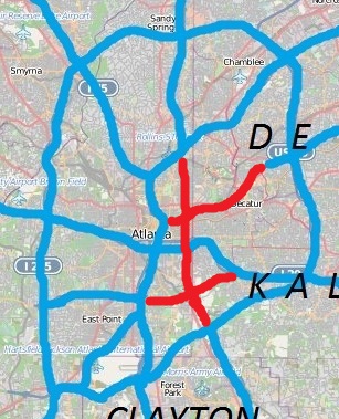
I-485/GA400
Open Street Map and own work (Keizers) – Open Street Map CC BY-SA 2.5
Construction of the perimeter began in 1963, just seven years after President Eisenhower signed the Federal Aid Highway Act of 1956 into law. Eisenhower, having experienced the German autobahn in WWII, was a fervid advocate for the Interstate Highway System. In 1955, approximately five months after the 1954 U.S. Supreme Court Brown v. Board of Education decision that ruled the premise of “separate but equal” in public education (and the public sector, at large) a violation of the Fourteenth Amendment, Eisenhower argued that the 40,000 mile interstate system was fundamental to national unity: “Our unity as a nation is sustained by free communication of thought and by easy transportation of people and goods … Together, the united forces of our communication and transportation systems are dynamic elements in the very name we bear—United States. Without them, we would be a mere alliance of many separate parts.”
With the support of Pres. Ike, the Federal Aid Highway Act established the program for funding and building the ambitious network of highways, bi-ways, cloverleaf interchanges, and junctions. That same year, in an article for Harper’s Magazine called “The New Super-Highways: Blessing or Blight?,” journalist Robert Moses foresaw the enormous impact this public works project would have on the nation, writing that “this new highway program will affect our entire economic and social structure. The appearance of the new arteries and their adjacent areas will leave a permanent imprint on our communities and people. They will constitute the framework within which we must live.”
The Interstate Highway System was a symbol of post-WWII optimism, prosperity, and, yes, unity.
Now, context is everything, and a cursory understanding of 20th century American history would reveal that the country was…not unified. De facto and de jure segregation existed across the nation. Despite economic prosperity sparked by WWII, patterns of economic deprivation and inequality plagued large sectors of the population, of all races. Acts of racial violence and intimidation were intended to preserve the status quo of white supremacy. There was a widespread hysteria of a Red Invasion. Folks organized resistance movements. Suffice it to say, things were pretty tense around here.
So, while in theory the Interstate Highway System may have represented unity, its actual implementation reflected the perpetual crossroads of American politics and society: the intersection of social and economic progress with the commitment to systemic white supremacist patriarchal capitalism on which our country was founded. The freeways, from their design to their demolition of lower-income, frequently African-American neighborhoods, reveal who we truly are.
In the decades following WWII, local officials and city planners across the country determined the paths the interstates would take, while the feds picked up 90% of the tab. In keeping with early-20th century zoning ordinances that established racial geographical boundaries, I-20 and I-285 wound through and around I-75/I-85. William Hartsfield, mayor of Atlanta from 1937 to 1941 and 1942 to 1962, took what was seen as a “racially pragmatic” approach, maintaining “the boundary between white and Negro communities” to prevent racial violence. Thus, in collaboration with a contingent of middle-class blacks from the financial and real estate industries, SWATS was born. The decades that followed would see persistent shifts in policies, practices, and demographics defining the ITP/OTP debate we have today.
All of this is to say that I-285 was a racialized border from the very beginning. And in many ways it still is—things have just gotten more complex.
As ITP has become whiter, OTP has become more diverse.
Coinciding with the arrival of the Interstate System was the beginning of white flight, and Atlanta’s white population plummeted between 1960 and 1990. No doubt, this initial white exodus is the root of the misconception that the Atlanta suburbs are exclusively white. Since the ‘90s, however, demographics have shifted massively both in the burbs and in town.
Whites may have flown north in the second half of the 20th century, but since the turn of the 21st, they’ve come home to roost. By the mid-90s, gentrification of the City of Decatur, Candler Park, and Inman Park was well underway. As an early gentrifier of Grant Park put it in a 1996 editorial for the Atlanta Business Chronicle, “In some ways, I\’m thankful that most white Atlantans would be scared to live where I do. Otherwise, I couldn\’t afford it. And then I, instead of them, would be spending the time in the car instead of eating breakfast and reading the paper.”
We all know how this turned out for Grant Park, where Zillow lists the current median home price at $481,450. And anyone who has driven through the ragtag mixture of boarded-up houses and renovated bungalows that lines today’s rapidly gentrifying communities—such as Capitol View or Mechanicsville—won’t be surprised to learn that Atlanta is home to the worst income disparity of any major U.S. city, according to a 2018 Bloomberg report.

As ITP has become whiter, OTP has become more diverse. This is, obviously, due in part to the ever-rising housing prices that have pushed out many of Atlanta’s longtime African American residents who can no longer afford their outrageous property taxes. As WABE has reported, “between 2000 and 2013, poverty in Atlanta’s suburbs had the highest rate of change of any metro region of its size.”
But the demographic shifts of the new millennium aren’t as simple as the reverse migrations of low-income African Americans and affluent whites. Metro Atlanta has one of the highest rates of black homebuyers in the nation; and it may be difficult for ITP folks to comprehend, but lots of these buyers choose to live in the suburbs, for as many different reasons as do their white neighbors. In his report on a 2019 Brookings Institute study, Brentin Mock points out that “Atlanta’s inner-ring suburbs have taken on so many majority-black areas that it has triggered some white neighborhoods to rope themselves off to start their own majority-white cities.”
Further belying the outdated black and white characterization of the perimeter are the metro area’s immigrant communities. In Gwinnett County, for instance, 21.5% of the population identified as Hispanic or Latino in the 2010 census. Clarkston, just east of I-285, has welcomed thousands of international refugees in the past two decades. Duluth has been called the “Seoul of the South.” In other words, if we genuinely care about immigrants, then we need to care about the suburbs in which they live.
We are on the cusp of turning this state blue, and it’s time to focus.
The fact is, cities outside the perimeter vary tremendously in terms of culture, socioeconomics, and demographics. John’s Creek is as different from Austell as Brookhaven is from East Point (a city that, like several others, straddles both sides of the perimeter).
And yes, of course there are areas outside the perimeter that are mostly white, mostly rich, and mostly conservative. Just like those northern ITP neighborhoods that voted for Trump in 2016 (looking at you, Buckhead).
But guess what? In 2016, our OTP hometown, Smyrna, went blue.
Listen up, y’all, because this is important: in the 2016 presidential election, Cobb voted Democrat. As did Douglas and Gwinnett Counties. Even quasi-rural Paulding County voted 45% for Clinton. We are on the cusp of turning this state blue, and it’s time to focus. Let’s save the borders and the walls and the hate for the other guys. With Georgia’s 159 counties and inexplicable, intricate systems of governmental districting, we don’t need to further complicate this mess by insisting that ITP and OTP are inherently at odds. When it comes down to it, I-285 is nothing more than a geographical reference point, a big road about six miles south of the Big Chicken.
After the 2020 Census, Georgia lawmakers will once again reconfigure our legislative and congressional districts. Scary stuff, considering that the 2019 Supreme Court ruling in two consolidated cases (Rucho v. Common Cause and Lamone v. Benisek,) essentially gave the greenlight to politically motivated redistricting and map manipulation. This means that if Republicans come out on top in 2020, we will have actual gerrymandering to worry about—so how about we not use the perimeter as a tool for cultural gerrymandering, too?
Because beyond the island of Atlanta proper, beyond the shallows of its surrounding suburbs, many of our rural communities might as well be out at sea. The poverty they face should shame the smugness right off ours—but from here inside the perimeter, we can’t even see them.